Grade 6
Earth Science
Students in Grade 6 start recognizing the need for accuracy in observation and measurement; and apply suitable methods to record, compile, interpret and evaluate observations and measurements. Students should be able to design and carry out an investigation in which variables are identified and controlled, and can test the scientific question being investigated.
Chapters covered in this course
Chapter 5: Changes over time Chapter 6: Conserving earth's resources Chapter 7: Weather and Climate Chapter 8: AstronomyLesson 1: Features on Earth
Water covers about 75% of the Earth's surface. This part of the Earth that contains water is called the Hydrospehre. Water can be solid (ice or snow), liquid (in oceans, lakes and other water bodies) and as water vapor in the atmosphere.
The Earth's water can either be fresh or salty. More than 95% of the water on the Earth is salty. Ocean water has salts such as sodium chloride amd magnesium chloride dissolved in it. You can use the word salinity to describe how much salt is dissolved in the water.
Earth's Landforms
A landform is a physical feature on Earth's surface. Each landform has specific characteristics and each landform forms in a different way.
Land Features
- A mountain is a landform that rises high above the surrounding ground. They form when rock layers fold or are pushed up by forces inside Earth. They may also form when volcanoes erupt.
- A hill is lower and rounder than a mountain.
- A valley is low land between hills or mountains.
- A canyon is a deep valley with high, steep sides.
- A cliff is a high, steep section of rock or soil.
- A plain is a wide, flat area of land. They include ocean plans which are found near the ocean, or inland plains, which are found in the middle of continents.
- A plateau is a flat land that is raised higher than the land around it. A plateau forms when forces inside Earth lift up a horizontal layer of rock.
- A desert is an area with very little precipitation.
- A beach is the land along the edge of a body of water.
- A dune is a mound or ridge of sand.
 Merti plateau in Kenya.

Water Features
- An ocean is a large body of salt water.
- A coast is where a body of water meets land.
- A tributary is a small river or stream.
- A river is a natural body of moving water.
- A waterfall is a natural stream of water falling from a high place.
- A lake is a body of water surrounded by land.
- An estuary is where river water and ocean water meet.
- A delta is the mass of land that forms at the mouth of a river.
- An inlet is a narrow body of water off of a larger body of water.
How to Map the Earth
Latitudes and Longitudes are necessary to precisely locate any place on the planet. Latitudes are a measure of how far a place is from the equator. The equator's latitude is 0 degrees (0°). The highest latitudes are at the North and South poles. Both are 90°. Longitudes show the location east or west of the prime meridian, the vertical line that passes through Greenwich, England. This line is also called the Greenwich Meridian.
To locate a place on the planet, find the latitude line nearest the city's lititude. If th city is between two latitude lines, estimate the distance between them. Latitude above the equator is north (N). Latitude below the equator is south (S).
Then find the longitude line that is closest to the longitude of the city. Longitude to the right of the prime meridian is east(E). Longitude to the left of the prime merdian is west (W). The point where the city's latitude and longitude lines cross is it's location. For example, the location of New York City is 41oN, 74oW.
Elevation
Elevation defines the height above or below sea level. On a map, elevation is shown by using contour lines. One contour line connects places a map that are of the same elevation. Elevation is used when describing alocation on the Earth. When the location of interest is in the air, the term altitude is used.
The Earth's Layers
The air around you is the Earth's atmosphere. The atmosphere includes all of the gases around Earth. All of Earth's liquid and solid water, including oceans, lakes, rivers, glaciers, and ice caps, makes up its hydrosphere. The hydrosphere covers approximately 70% of the Earth's surface.
Like an egg, Earth has several layers. The continents and ocean floor make up Earth’s outermost layer, called the crust. The crust is Earth’s thinnest and coolest layer. The layer below the crust is the mantle. Part of the mantle is solid rock. Part is nearly melted rock that is soft and flows. It is a lot like putty. At the center of Earth is the core. The core is the deepest and hottest layer of Earth. The outer core is melted rock. The inner core is solid rock. The biosphere means the parts of Earth where living things are found. Organisms have been found from the atmosphere to the ocean floor.

Lesson 2: Earth's Moving Continents
Continental Drift
In 1915 Alfred Wegener, a German scientist, published his book after noticing that the different large landmasses of the Earth almost fit together like a jigsaw puzzle. The continental shelf of the Americas fits closely to Africa and Europe. Antarctica, Australia, India and Madagascar fit next to the tip of Southern Africa. He presented his Continental Drift hypothesis on 6 January 1912. He analysed both sides of the Atlantic Ocean for rock type, geological structures and fossils. He noticed that there was a significant similarity between matching sides of the continents, especially in fossil plants.
Wegener concluded that all the continents had once been part of a single 'supercontinent.' He called this landmass a Primal continent or Pangaea (a greek term meaning All-Lands or All-Earth. He proposed that the mechanisms causing the drift might be the centrifugal force of the Earth's rotation. This concept became known as Continental drift.
Plate Tectonics
During Wegener's time, there was widespread rejection of the continental drift theory among geologists until the 1950s when additional evidence was discovered to prove his theory. Scientists developed a model called plate tectonics to explain how the continents and the ocean floor could move. According to this model, the Earth’s surface is broken into pieces, or plates. The plates move over the hot, fluid rock, or magma, in the mantle. The slow movements in the fluid part of the mantle drag the lithosphere and its plates sideways. As the lithosphere moves, so do the ocean floor and continental plates.

As some crustal plates move apart, magma enters the cracks and flows outward. The magma cools, hardens, and builds up into parallel ridges, or raised structures, on the ocean floor. The new rock exerts a sideways force called compression. Magma continues to flow between the plates, forcing them farther apart. This process is called seafloor spreading.

Types of Plate Boundaries
Plates can move in three ways, they can move apart from each other, they can collide or the can slide past each other.
Divergent boundaries (also called constructive boundaries or extensional boundaries) are where two plates slide apart from each other. As the ocean plate splits, the ridge forms at the spreading center, the ocean basin expands, and finally, the plate area increases causing many small volcanoes and/or shallow earthquakes. At zones of continent-to-continent rifting, divergent boundaries may cause new ocean basin to form as the continent splits, spreads, the central rift collapses, and ocean fills the basin. For example the East African Rift.

The image below shows the Arabian and the Nubian plates drifting apart. Similar drift can be observed in the East African Rift.

Convergent boundaries ( also known as destructive boundaries or active margins) occur where two plates slide toward each other to form either a subduction zone (one plate moving underneath the other) or a continental collision. Subduction zones are of two types: ocean-to-continent subduction, where the dense oceanic lithosphere plunges beneath the less dense continent, or ocean-to-ocean subduction where older, cooler, denser oceanic crust slips beneath less dense oceanic crust. At zones of ocean-to-ocean subduction a deep trench to forms in an arc shape. The upper mantle of the subducted plate then heats and magma rises to form curving chains of volcanic islands e.g. the Aleutian Islands, the Mariana Islands, the Japanese island arc. At zones of ocean-to-continent subduction mountain ranges form, e.g. the Andes, the Cascade Range. At continental collision zones there are two masses of continental lithosphere converging. Since they are of equal density, neither is subducted. The plate edges are compressed, folded, and uplifted forming mountain ranges, e.g. Himalayas and Alps.


Transform boundaries (also called conservative boundaries or strike-slip boundaries) occur where plates are neither created nor destroyed. Instead two plates slide, or perhaps more accurately grind past each other, along transform faults. The San Andreas Fault in California is an example of a transform boundary exhibiting dextral motion.


Lesson 3: Forces That Build the Land
In the previous chapter, we described three types of tectonic plate movements and how they can influence the geography of the continents. When two plates slide past each other, they can result in shearing forces that work like the blades of a pair of scissors and can cause rocks to break. At divergent boundaires, plates separate from one another and result in tension forces on the rocks. When tension forces exceed the rock's strength, the rock breaks and forms a fault. A Fault is a break or a crack in the rock of te lithosphere along which movements take place. Faults are frequently located along the boundaries of tectonic plates.
There are three kinds of faults:
- Shearing foreces result in strike-slip fault.
- Tension forces produce normal faults. a normal fault occurs when the rocj above the fault moves down.
- Compression forces result in reverse faults, where the rock above the fault moves up.

Mountains form when plates push against each other. Mountains made up mostly of rock layers folded by being squeezed together are called folded mountains. Mountains mad by huge tilted blocks of rock separated from the surrounding rock by faults are called fault-block mountains. A plateau occurs when a large area of the Earth's crust is pushed upwards forming a flat raised area on the land.
Earthquakes
The forces at plate boundaries cause stretching, pushing and bending responses on large sections of rocks. This can build up energy and when the rock breaks, energy is released (the same way an elastic band releases energy when it snaps after being stretched to its limit). When this energy is released, it causes the earth curst to move resulting in earthquakes.
The point below the earth where an earthquake begins is called the focus. The location on the earth directly above the focus is called the epicenter. People living near the epicenter will feel the earthquake first and most intensely. Earthquakes may include many smaller movements called aftershocks, that can last for days or even weeks.
Earthquakes (and volcanic eruptions) create vibrations that travel through the earth resulting in earthquake waves calles seismic waves.
Understanding Seismic Waves
There are two main types of seismic waves; surface waves and body waves. surface waves occur near the surface of the earth. Tehy travel on the surface of the earth slowly like ripples and are the most destructive waves. Body waves travel deep in the interior of the Earth. There are two types of body waves, primary waves (p waves) and secondary waves (s waves). P waves are the fastest seismic waves. They travel through gases, liquids and solids by pushing and pulling against the material they pass through. During movement, they cause the material to compress and stretch through their pushing and pulling forces. P waves move in the same direction as the shaking rock. S waves are slower than P waves and travel only through solids. They cause the marial to move eithe rup and down, or side to side. Therefore S waves vibrate at right angle to the direction of their movement.
Seismic waves can be detected, measured and recorded using a Seismograph.

The measurements of the seismograph can be used to locate the earthquake's epicenter by measuring how much time it takes for the waves to be detected by various earthquake monitoring stations close to the affected area. To find the location, three stations are needed. The distance is charted around each station in a circle. The point where the three circles intersect is the epicenter.

Earthquake Magnitude
The height of the wave on a seismogram indicates the magnitude of the earthquake and is a measure of the energy released during the earthquake.
There are two measures of earthquakes; The Richter scale and The Mercalli scale. The Richter scale measures earthquakes on a scale of 1-10. An increase of 1 on the scale means a tenfold increase in magnitude. The Mercalli scale rates what people feel and observe so it subjective and not reliable.

Tsunamis
A tsunami (Japanese for harbor wave) is a series of waves in a water body caused by the displacement of a large volume of water, generally in an ocean or a large lake. Earthquakes, volcanic eruptions and other underwater explosions. In the open ocean, tsunamis move at speeds of 500 to 1,000 kilometers per hour. However, a tsunami slows down as it approaches a shore. The length of each wave decreases, but the height increases. The water piles up, and it is often pulled away from the coastline as the tsunami approaches land. Finally, the tsunami crashes onto the shore as a giant wall of water.
Volcanoes
Volcanoes are formed by powerful forces within Earth. As one crustal plate moves under another, the rock in the mantle and lower crust melts and becomes magma. Melting rock produces gases that mix with magma. Over time, the gas-filled magma rises, because it is less dense than the solid rock around it. Rising magma can build up in a weak part of overlying rock, forming a magma chamber. Magma chambers are the reservoirs from which volcanic materials erupt. When magma reaches the surface, it erupts through a central opening called a vent. Once magma reaches the surface, it is called lava.
Types of Volcanoes
There are three main kinds of landforms produced by volcanic eruptions.
1. Cinder cone volcano is a landform mainly made up of small rock particles, or cinders. As erupting lava shoots into the air, it breaks into small pieces. These fragments cool and harden as they fall back to the ground. The fragments pile around the vent, forming a cone with steep sides.
2. Shield volcano is a landform made up of many layers of rock. As fluid lava flows out to the surface from a vent, it spreads out in all directions, cools, and hardens into rock. Multiple layers of lava rock build up to form a volcano with broad, gently sloping sides.
3. Composite volcano is a landform made up of layers of thick lava flows alternating with layers of ash, cinders, and rocks. These layers form a symmetrical cone with steep sides that are concave, or curving inward.

Other Volcanic Landforms
An island arc is a string of island volcanoes which occurs when one oceanic plate is driven under another. Part of the sinking plate melts, and magma moves up through the crust along a line parallel to where the plates meet.

Rift volcanoes form where plates move apart and volcanoes form at gaps along the plates’ edges.
Dome mountains form when magma rises and pushes against rock layers above it forming large dome shaped mountains. The black hills of South Dakota are good examples.

If magma hardens in vertical cracks across horizontal layers, a dike forms. When magma hardens between horizontal layers of rock, a flat sill is formed.

Lesson 4: Forces That Shape the Earth
Weathering
Weathering is the process where rocks break down into smaller pieces through natural processes. Weathering may either be Physical, chemical or biological.
Physical Weathering is also called mechanical weathering. Physical changes such as freezing water, moving water etc cause rocks to break down. When water sips into a crack in a rock and then freezes causing the rock to break apart it is called frost wedging. When the ice melts, the water sips even deeper into the crack and causes the rock to break down even further.
Moving water carries with it pieces of rocks and they collide against each other as they move. These collisions and the force of the water itself makes the rocks break apart causing weathering.
Biological weathering: This occurs when weathering is as a result of the direct involvement of a biological material. Animal hooves break down rocks into small particles. Plant roots also penetrate between tight rock spaces causing the rocks to crack as the plant root grows. burrowing animals such as ants and worms result in conditions that make weathering easier to occur. For example they might bring rock pieces to the surface. Or they create burrows whare ice can accumulate and cause further cracks.
Chemical Weathering: Some of the forces that cause weathering are chemical in nature. For example oxygen and acids are effective at causing chemical weathering. Rocks contain iron which reacts with the oxygen in the air resulting in rust which is easier to break down. When carbon dioxide in the air dissolves in water, it forms weak carbonic acid which results in acid rain. Acid rains can react with limestone and dissolves it and transports it as it flows.
Some other forces shape the Earth's surface by moving materials from one place to another. Erosion is the process where rock pieces and other particles are moved from one place to another either by wind or water. Deposition is the dropping off of particles in another location. Wind can cause erosion and deposition and these processes can result in other landforms such as sand dunes.
Flowing water is a major cause of eriosion. It carries particles as it flows downhill. The faster a river flows the larger the particles it can carry. When the river flows slowly, some of the particles are deposited as sediments. Deposition can cause a river to change course or to meander. Rivers with steep slopes that move faster are always straighter.
Two other causes of erosion are gravity and glaciers. Gravity can pull large masses of soil downhill in a process called mass wasting. Glaciers, on the other hand, move over the land like huge bulldozers and they scrape the surface of the soil and carry rocks in front of them and to their sides.
As a river travels, it carves the land surface and forms a channel. The river erodes the surface slowly and over time can result in deep canyons and valleys. Eventually the sediments reaches the sea and is deposited offshore.
Glaciers form when ice builds up over several years and when it reaches about 100m deep it becomes too heavy and begins to flow downhill. It scrapes the surface of land as it moves. Once it reaches the edge of the continent it breaks off and forms icebergs.
When glaciers move, rocks and other substances carried by the glacier are deposited as a mixture called till. As a glacier melts, till is deposited in front of or along the sides of the glacier. These deposits often take the form of a ridge or mound, called a moraine
Soil
Soil is a mixture of minerals, weathered rocks, and other things. It has bits of decayed plants and animals called humus. So we can define soil as consisting of organic and inorganic material. Organic material are those coming from or having to do with living things, such as decaying plant and animal material. Inorganic materials do not come from living things, such as minerals and weathered rocks.
The making of soil starts with weathering. Weathering causes rocks to break down into smaller and smaller pieces. The tiny bits of weathered rock build up into layers.
Soil Layers / Horizons
Generally, soil can be divided into three horizons; A, B and C.
The A horizon contains most of the nutrients and humus. The nutrients in the humus are used by plants to grow. In addition, the humus absorbs water and keeps it for a longer period of time and releases it to plants. The soil in this layer is called topsoil.
The horizon B is called subsoil. This layer contians less humus and more particles of rocks.
The C layer is mostly made of larger pieces of rocks. This layer sits on solid unweathered rock called bedrock.
Different places have different depths of each soil layer, and some areas may even lack one of the layers totally.
Soil in different places has different properties and each type of soil has different amount of nutrients and can support different plant and animal life. The soil in a forest has a thin layer of humus and topsoil. Frequent rains carries minerals deep into the ground. Crops with shallow roots do not grow well in such environments because their roots cannot reach the minerals. Desert soil is sandy and does not contain much humus. Because of the sarce rains in the desert, plants here have special adaptations to survive. Desert soil, however, is rich in minerals because they are not washed away by rain water. Plants may grow in deserts if they are supplied with water artificially (irrigation). The grasslands are good for crops such as wheat, rye and corn. The soil is rich in humus, which provides nutrients for the plants. Animals feed on the grasses and also drop their waste on the ground, which adds to the organic matter.
Soil is a resource that can be wasted through processes like erosion. Plants roots help to keep the soil aggregated and prevents erosion. Plants obtain nutrients from the soil as they grow, and they replace them when they die. If farmers remove all crops from the land, they are removing the nutrients from the land and over time the land becomes less able to support new crops.
Lesson 5: Changes in Geology over Time
Fossils and Rocks
Fossils are the remains of ancient organisms preserved in soil or rocks. When an organism dies and are covered in soil, sand or other sediments, the sediments harden over and around the organism's remains. Almost all fossils are found in sedimentary rocks. Scientists can study fossils to understand the characteristics of organisms that lived many years ago. These characteristics may also be used to determine the environmental conditions that were present many years ago.
Fossil fuel is a material that formed from the decay of ancient organisms and is used as a source of energy. For example, decayed parts of ocean organisms were buried deep under the ocean. There, a combination of the weight of rock, heat, and the action of bacteria turned the decayed materials into oil and natural gas. Oil and natural gas also are fossil fuels.
Scientists can estimate the age of fossils by observing the layers of the sediments. Fossils found on the top layers are more recent, were deposited more recently, than fossils found deeper in the sediments. This is called relative age. The word relative, means it has been estimated in comparison to something else. The Absolute age of a fossil is the actual age in years. It can be estimated by estimating the age of the rock layer where the fossil was found. The age of the rocks is estimated by the amounts of various elements. The concentration/amount of certain elements reduces at a contant way. For example, lets say it takes 1 million years for half of element A to change into Element B. After 1 million years, the rock contains equal amounts of element A and B. This time point is called an element's half-life. As mentioned, during the first half life, you will observe equal amounts of Element A and B. During the second half-life, more Elemebt A will be converted to Element B, so by the 2 million year mark, there will be 75% of element B and 25% of element A. at the 3 million year mark, there will be 87.5% of element B and 12.5% of element A. Notice that at every subsequent half-life, the concentration of element A is halfed. Different elements different half-lives.

Using the relative age of fossils and rocks, scientists estimated that the age of the earth is around 4.6 billion years. during those 4.6 billion years, there has been several eras. An era is a unit of time measured in millions of years. Geological periods divide eras into shorter periods of time where specific major geological events occured.
Geological Timescale
The geologic time scale is a system of chronological dating based on the rock record. It classifies geological layers to describe the timing and relationships of events in geologic history. Over hundreds to thousands of millions of years, continents, oceans and mountain ranges have moved both vertically and horizontally. Areas that were once deep oceans hundreds of millions of years ago are now mountainous or desert regions.

Chapter 6: Conserving Earth's Resources
Lesson 1: Rocks and Minerals Lesson 2: Air and Water Lesson 3: Other Land Resources Lesson 4: Saving Earth's ResourcesLesson 1: Rocks and Minerals
A mineral is a solid, nonliving substance found in nature. Minerals are the building blocks of rocks.
There are more than 3000 kinds of minerals. Each mineral has its own properties.
Properties of Minerals
- Color: Most minerals have only one color. A few like Quartz have many colors.
- Streak: Streak is the color of the powder left when a mineral is rubbed across a white tile. A mineral's streak may or may not be the same as the same minerals color.
- Luster: This is how light bounces off a mineral. Some minerals are shiny like metal, others are dull.
- Hardness: This is a measure of how easily a mineral can be scratched. Some minerals are soft and can be scratched with a fingernail. Others are hard and cant even be scratched by a metal.

A rock is a non-living material made of one or more minerals. There are several types of rocks. SOme rocks are made of many minerals while others are made predomrinantly by one mineral.
Rocks are made of grains that give the rock its texture. Some rocks have large grains that can be seen easily with just the eyes. Such rocks end up having a rough/coarse texture. Other rocks have fine grains and as a result have a fine/smooth texture.
There are three main kinds of rocks.
- Igneous rocks form when melted rock cools and becomes hard. The molten hot rock inside the earth is called Magma. When this magma flows onto the surface of the earth it is called lava. Lava cools and hardens quickly and results in a rock with smooth grains. When magma cools slowly below the earth surface, it forms granite, which has a corse texture.
- Sedimentary rocks form by sediments of weathered rock or fossils. Sandstone, limestone and shale are examples of sedimentary rocks.
- Metamorphic rocks are rocks that have changed by heating and squeezing. Deep inside the earth, the heat and pressure/weight from other rocks creates the heating and squeezing needed to create metamorphic rocks. A new rock forms with properties that are different from the original rock.
Rocks and minerals have multiple uses from building houses, making jewelry and other even more common uses. The mineral graphite is used to make pencil points. Aluminum is used in cooking pans, and electric wires. copper is used in making coins, electric wires and water pipes. Calcium, a mineral which is found in milk, is essential for bone development. It is also predorminant in limestone and may be used to make chalk.
Minerals are usually made of crystals. A crystal is a solid that has a structure arranged in orderly, fixed patterns. A crystal’s shape depends on the way its structure is arranged.
Scientists generally begin identifying a sample by examining the shape of the mineral’s crystal structure. The way a mineral breaks is another important property. Some minerals tend to break along flat surfaces. This property is called cleavage. Cleavage is described by the number of planes, or directions, along which the mineral breaks. The cleavage of a mineral depends partly on its structure.
The rock cycle is the process that describes the gradual transformation between the three main types of rocks: sedimentary, metamorphic, and igneous. It is occurring continuously in nature through geologic time.
Steps in the Rock Cycle:
- Formation of Igneous Rock – Melting, Cooling, and Crystallization.
- Formation of Sedimentary Rock – Weathering, Erosion, Sedimentation, and Compaction.
- Formation of Metamorphic Rocks – Metamorphism.
- Weathering.
- Transportation.
- Deposition.

Lesson 2: Air and Water
The Water Cycle
The water cycle is made up of three manin processes.
- Evaporation
- Condensation
- Precipitation
Evaporation
When water heats up, some of it changes into a gas called water vapor. This process is called evaporation.
Water evaporates from lakes, oceans, rivers, ponds and other water bodies.
Water can also evaporate from the surface of leaves in a process called transpiration.
Condensation
The water vapor travels in the air. As it rises into the air, it cools down and turns back into a liquid. The change from gas to liquid is called Condensation.. If many water droplets in the sky come together they form clouds. A cloud is a group of water droplets in the atmosphere.
Precipitation
The water in the clouds and the water vapor in the air will then fall down to the ground as rain or other kids of precipitation.
Precipitation refers to any liquid or frozen water that forms in the atmosphere and falls back to the earth. It comes in many forms, like rain, sleet, and snow.
If its too cold, the water droplets in clouds will freeze into ice. Freezing refers to the change from liquid to solid.
Some of the water that falls as precipitation collects on land and flows downhill. A watershed is an area from which water is drained. Precipitation that flows across the land’s surface and is not absorbed will flow into rivers, lakes, and streams as runoff. Most of the water will flow from rivers to the ocean. Some of the water will settle underground and become groundwater.
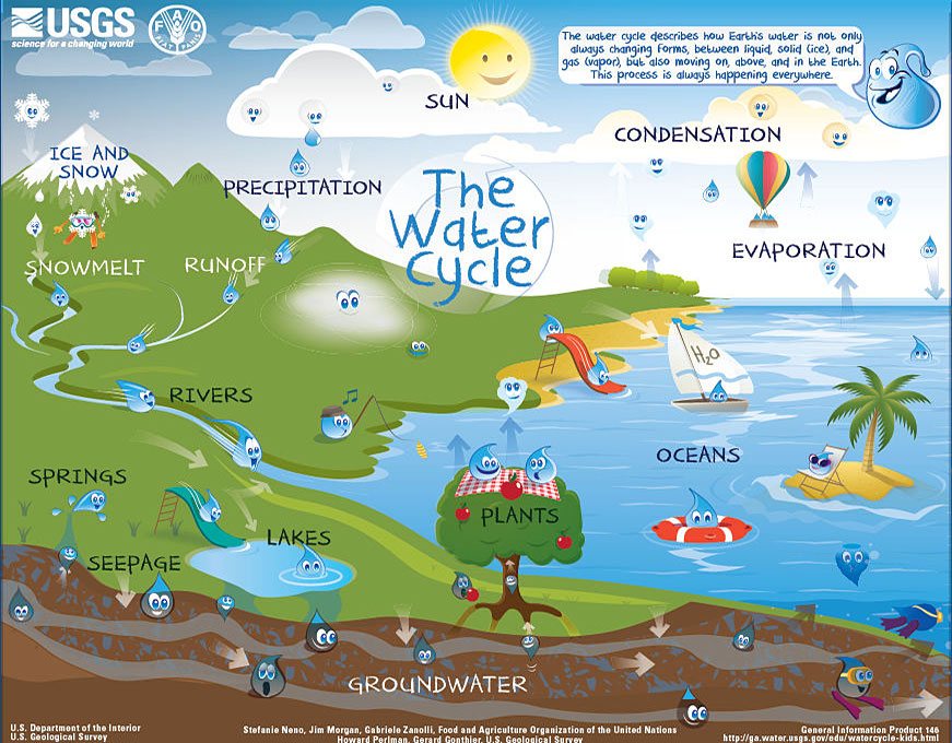
Plants and animals also play a role in the water cycle. Plants absorb water from the ground through their roots. Excess water in the plant is lost through transpiration. Animals drink water and then release the excess as waste and sweat.
Approximately 70% of the Earth's surface is covered with water. However, because most of this water is in oceans, it is salty. In fact, 90% of the earth's water is salty. About 2.5% of the Earth's water is frozen at the North and South poles. About 0.1% of the water is in the air as water vapor. Only 0.6% of the Earth's water is fresh liquid water. Many living things utilize the fresh water to survive. Most of the fresh water is obtained from running water, standing water and groundwater.
Running Water
Many cities are built close to sources of running water such as rivers or streams. running water is a source of fresh water for homes, businesses and farms.


Standing Water
Standing water includes bodies of water such as lakes and reservoirs. A reservoir is an artificial lake built to store water. Reservoirs are usually made by building a dam across a river. The water is stored behind the dam and is released when needed.
Groundwater

 Water seeps into the ground through aquifers. An Aquifer is an underground layer of rock or soil that has pores and is capable of absorbing water. When the seeping water reaches a layer of rock that does not have pores, it settles there builds up and can be used by humans by drilling or digging into the ground. Once ground water has been harvested, more water must seep from the surface so as to replace the ground water again.
Some countries/regions use water for irrigation. Irrigation is supplying water to agricultural farms by artificial means.
The water used in most homes is supplied by a water company. The water usually undergoes some treatment processes then pumped through pipes into homes and businesses. Some homes may use well water. A well is used to obtain groundwater by drilling and installing a pipe deep into the ground and pumping water to the surface. This water may undergo treatment and then used for human consumption. Otherwise, well water may also be provided to farm animals.
Drinking water should be free from contamination. You should be on the look out for possible contamination in water, such as a change in color (fresh water should be clear), visible dirt in the water, any smell in the water (fresh water should not have any smell - odorless).
Cleaning Water
The water that runs in most homes is usually treated in a water treatment plant to remove contaminants. Water is first obtained from a fresh water source such as a reservoir or a lake and then it is run through several tanks, with each tank having a different function. The steps may vary with there the water was obtained from.
The first step is to remove dirt through a process called coagulation. This involves the use of sticky particles to attract the dirt.
The next step involves sedimentationwhere clumps of dirt and the sticky particles sink to the bottom of the tank.
The water then is passed through a series of filters made with layers of sand, gravel, and charcoal. These remove more particles from the water. Afte this tank, chlorine is added to the water to kill harmful bacteria. This step is called disinfection. The clean water is stored in tanks until it is pumped to homes and businesses.
Conserving and Protecting Water
Water conservation refers to all efforts made to reduce the waste of water. This may be targeting a small scale level at the individual level, like showering for a shorter time. Conservation can also be aimed at a larger scale, like a lake or a watershed.
Water protection involves the use of government regulations to limit the uses of water. For example, a government may restrict the use of water to domestic uses only and regulate the use of water for irrigation such as watering the lawn.
Air
The Earth's atmosphere holds the gases that living things need to stay alive. You cannot see air (its invisible), you cannot smell air (its odorless) and if air is not moving, you cannot feel it. Air is made up of Oxygen, carbon dioxide and nitrogen. Plants take in carbon dioxide and with the help of sunlight, they are able to make the food they need to survive. Some bacteria in the soil can convert nitrogen into forms that plants can absorb and use to grow.
Air pollution occurs when toxic gases, dust or chemicals are released into the atmosphere from vehicles, factories, mines and other sources. Smog is a type of air pollution caused by oarticles and gases from burning fossil fuels in factories/industries.
Some gases and chemicals have been shown to affect the ozone layer. The ozone layer is a layer of ozone gas (similar to oxygen) found about 30 kilometers above the earth's surface. It protects the earth from dangerous energy from the sun. Some pollutants from air conditioners, aerosol cans have been shown to destroy the ozone layer. The destruction of the ozone layer results in dangerous radiations from the sun reaching the earth's surface and these may be associated with the occurrence of skin cancer.
Lesson 3: Other Land Resources
Earth's natural resources can be classifed as either renewable or nonrenewable depending on much time it takes to replace them. Renewable resources include water (which can be replenished fast) or solar energy (which is continuously supplied by the sun). Nonrenewable resources include minerals, petroleum, coal etc, which either cannot be replenished, or it would take a very long time to replace them. Nonrenewable resources also tend to be available in limited quantities, or are used up faster than they can be replaced. Trees grow relatively fast and can be grouped as renewable resources. However, if the population cuts down trees faster than the amount of time it takes for them to grow, then the trees can be regarded as nonrenewable. This explanation also applies for wildlife and fish if they are harvested faster than the time it takes to replenish them.
Rocks, Minerals and Soil
A rock is a non-living material made of one or more minerals. There are several types of rocks. Some rocks are made of many minerals while others are made predominantly by one mineral. Rocks are made of grains that give the rock its texture. Some rocks have large grains that can be seen easily with just the eyes. Such rocks end up having a rough/coarse texture. Other rocks have fine grains and as a result have a fine/smooth texture.
Rocks that contain useful substances, such as minerals, are known as ores. People mine for ores so as to obtain the valuable minerals from them. Some minerals are used as gems. Gems are minerals that are rare and beautiful such as diamonds, emeralds, sapphires, and rubies etc. Quartz, which is usually found as sand, is used to make concrete and glass. Quartz contains silicon, the element used in the production of computer chips. Pieces of quartz are used in watches and clocks. Energy from a battery keeps the quartz vibrating steadily, and this makes the watch or clock keep very accurate time. Crystals of quartz, mica, and other minerals can be found in granite, a hard rock used in buildings. Minerals also make up marble, a rock that artists use frequently to make statues and monuments.
Fossil fuel is a material that formed from the decay of ancient organisms and is used as a source of energy. For example, decayed parts of ocean organisms were buried deep under the ocean. There, a combination of the weight of rock, heat, and the action of bacteria turned the decayed materials into oil and natural gas. Oil and natural gas also are fossil fuels. Limited deposits of oil and natural gas exist in North America, the Middle East, Indonesia, and Venezuela. Once these deposits are used up, they will be gone.
Soil is a mixture of minerals, weathered rocks, and other things. It has bits of decayed plants and animals called humus Humus is dark in color. It adds nutrients to soil. Plants use these nutrients for their growth. Humus works like a sponge to soak up rainwater and keep the soil moist. Water, air, and living things are also found in soil. The making of soil starts with weathering. Weathering causes rocks to break down into smaller and smaller pieces. The tiny bits of weathered rock build up into layers. The top layer is called topsoil. Topsoil is dark and has the most humus and minerals. Below the topsoil is subsoil. This layer is lighter in color and has less humus. Below the subsoil is bedrock, or solid rock.
Pollution
Pollution is a harmful change to the natural environment. Pollution occurs because Earth’s land, water, and air have a limited capacity to absorb wastes and to recycle them naturally. People may hamr the soil through activities such as mining for minerals, oil spills and other contaminants. Leaving the soil bare results in soil erosion either by wind or by moving water. When soil is left bare, it also becomes degraded faster due to lack of organic matter. Planting the same crop on the same land in successive years means the same nutrients are taken up by the crop every year, leaving the land infertile. This has forced many farmers to utilize large amounts of fertilizers, which, although they increase the nutrients, they do so only for specific elements, Usually Nitrogen, phosphorus and sulfur. This helps plants grow but does not necessarily increase organic matter in the soil. Cutting down trees results in the loss of roots that would have held the soil together and therefore results in erosion. Land use changes resulting from urbanization, changing agricultural land into homes for expanding urban populations can harm ecosystems and means that land is no longer available for food production.
Human activities such as bathing, washing clothes, flushing toilets or sending harmful residues into water can harm water resources. Some factories may dump watses and chemicals into lakes and rivers. Agriculture producers usually use fertilizer and pesticides on their farms and some of these chemicals can dissolve in rain water and get washed away into rivers, lakes or ponds. These residues may be conusmed by fish or birds. Fertilizer deposited in water bodies can affect ecosystems leading to increased growth of algae which is usually observed as green coloration in water. When the algae die they use up oxygen from the water as they decompose, resulting in reduced oxygen levels available to fish.
Cars and factories release smoke into the atmosphere, which sometimes combines with fog to form smog. Smog irritates the eyes and throat and could affect people with pre-existing respiratory problems.
Acid rain forms when nitrogen, sulfur and carbon gases produced by burning fossil fuels combine with water vapor in the air forming acids. The acids fall to earth as acid rain or snow. Acid rain can pollute water and soil, kill plants and fish and damage the stone and metal used to build houses or statues.
Proper disposal of garbage and waste
The garbage produced by people and industries is disposed depending on the type of waste. Most garbage ends up in landfills. Landfills are usually covered in soil when they are full. Under the right conditions, the garbage deposited in landfills decomposes slowly and safely. In other areas in the world, garbage is deposited in open pits and left to rot slowly. While in other areas, garbage is burnt in incinerators that produce large amounts of smoke.
Household garbage like left over food, fruits and vegetables, garden waste may be biodegradable. These can be used to make compost, which can be reused in gardens to plant various crops.
Toxic waste from industries may be poisonous and must be disposed off according to the regulations or manufacturer's guidelines.
Common household items such as batteries, paint, cleaners, oils should be disposed off according to the regulations/directions.
Some countries have recycling programs where some materials such as food grade plastic bottles, packaging boxes and glass bottles are purchased and recycled.
Lesson 4: Saving Earth's Resources
Resources are scarce and precious and must be protected so as to benefit multiple generations. People have developed many ways to protect soil. For example, after harvest, farmers add humus or decomposed organic material to replace the nutrients that were removed by the previous crop. Farmers can also add animal manure or compost. This adds organic matter to the soil to help crops grow. Crop rotation is a practice where farmers grow different crops every year. This way, the crops are not utilizing the same nutrients from the soil every year. Planting legumes such as peas and beans on the land helps the land to obtain nitrogen from the air reducing the need to provide nitrogen through fertilizers. Some farmers plant grass between the roas of cash crops as a way to prevent soil from staying bare. If the farm is on a slope, farmers can build terraces to reduce soil erosion and allow planting crops.
Alternative energy sources include sources of energy other than fossil fuels. These can include:
- Geothermal energy: This energy source relies on the heat in the Earth's interior. The heat in the Earth's interior heats water and the steam or hot water provides geothermal energy. This type of energy can be used in some areas to heat homes and produce electricity.
- Wind energy has now become an important alternative to fossil energy. Windmills use moving air to spin wind turbines that then generate electricity. Many windmills can be installed to generate electricity for homes and businesses.
- Bioenergy utilizes biomass such as corn, sugarcane and other biological waste in a process called biomass conversion to generate alcohol based biofuels such as ethanol, or heat. Some organic matter produces methane (biogas), which can be burned for cooking or heating homes.
- Running water can also be used to produce 'hydroelectricity'. Many dams all over the world have hydroelectric plants.
- The Sun provides the largest amount of energy for Earth. Plants use energy from the Sun to produce food. People harness the power of sunlight by using solar cells, devices that use sunlight to produce electricity.

 (Source TILLEY et al. (2014))


Recycling
We can help protect Earth’s land, water, and air by following the 3 Rs of conservation: reduce, reuse, and recycle.
We can reduce the amount of natural resources we use. We can reduce the fuel used for heating and air conditioning by adjusting indoor temperatures to use less heat in cold weather and less air conditioning in hot weather. We can also design cars that need less fuel for the same driving distance (more fuel efficient).
Reusing materials saves resources. We can reuse many products. We can use washable tableware instead of disposable cups, dishes, and plates.
Recycling reduces the amount of energy needed to make things and also reduces the amount of garbage we produce.
Chapter 7: Weather and Climate
Lesson 1: The Atmosphere and Weather Lesson 2: Precipitation and Clouds Lesson 3: Predicting Weather Lesson 4: ClimateLesson 1: Atmosphere and Weather
Air is a mixture of gases that surrond the earth like a blanket. This layer is called the Atmosphere The air on earth consists of three main gases, Oxygen, Nitrogen, Carbon dioxide and water vapor. Without these gases, there would be no life on earth. Air that moves from place to place is called Wind. wind can be gentle and can also be strong and destructive. The earth's atmosphere is made up of several layers. The layer closest to the earth surface is called the Troposphere. This is a thin layer but all of life lives in this layer. The Stratosphere is located above the troposphere. Temperatures here are a bit warmer than the troposphere.
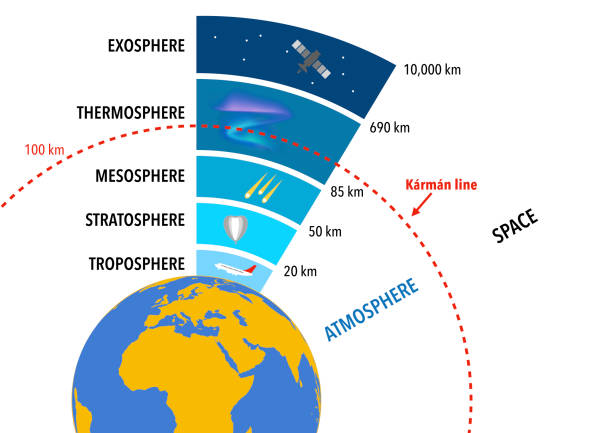
Jet airplanes normally fly within the stratosphere, just above the troposphere, because it is very stable. The stratosphere contains the ozone layer. The ozone layer absorbs harmful rays from the Sun. Rock fragments from space often burn up in the next layer, the mesosphere. The coldest temperatures in Earth’s atmosphere are found at the top of the mesosphere. The outermost layer, the thermosphere, is where space shuttles orbit.
Properties of Weather Weather is the condition of the atmosphere at an given time and place. Some of the properties of weather include: Temperature: describes how hot or cold it is. When the suns energy hits the ground, the surface warms the air above it and the air temperature increases. A thermometer is used to measure temperature. Humidity: is a measure of how much water vapor is in the air. Deserts have low humidity while rain forests have high humidity. Areas close to an ocean or large lakes also have high humidity due to evaporation from the ocean. Humidity is measured using a hygrometer. Air pressure: Air pressure is the force that air pushes on the surface of the earth. Air pressure is measured by an equipment called Barometer. Precipitation: Any form of water that falls from clouds is called precipitation. This includes rain, snow, sleet and hail. A rain gauge is used to measure the amount of rainfall. Wind: Wind is air in motion. The wind speed if an important property of weather. It can influence how cold it feels (wind chill). It can result in faster evaporation of water from oceans and lakes. The direction of wind is measured using a wind vane and the speed of wind can be measured using an Anemometer.
Insolation is the amount of the Sun's energy that reaches Earth at a given time and place. The angle of insolation is the angle at which sunlight hits Earth's surface. The larger the angle, the more intense the Sun's rays. Insolation also varies during the course of a day.
Air Pressure:
Air particles have mass, and so Earth’s gravity attracts them. Air pressure is the force exerted on a given area by the impacts of gas particles in constant motion. Standard air pressure, or the air pressure at sea level, is about 1 kilogram per square centimeter.
Earth's air pressure varies. As you move higher in the atmosphere, there is less air above you. Because there are fewer air particles above you that are being pulled toward Earth by gravity, there is less air pressure. Air pressure is an important weather variable. Air pressure variations help produce wind.
A convection cell is a circular pattern of rising air, sinking air, and wind.
Sea breeze is wind that blows from the sea to the land. At night, air over land cools faster than air over water.
A land breeze is wind that blows from the land to the water.
The direction of wind is measured using a wind vane or weather vane and the speed of wind can be measured using an Anemometer. A weather vane is a movable arrow which points in the direction that the wind is blowing.
Global Winds
Generally, wind blow from areas of higher pressure to areas of lower pressure. However, the Earth's rotation also pushes the winds to either the right or the left. This shift is called the Coriolis effect. The Coriolis effect causes winds in the Northern Hemisphere to curve to the right, or clockwise. In the Southern Hemisphere, the Coriolis effect causes winds to curve to the left, or counterclockwise.
Trade Winds
Trade winds are winds that blow toward the equator and are curved to the west by the Coriolis effect. These winds are referred to by the direction from which they come—northeast or southeast. The winds that blow toward the poles are curved to the east. Because they seem to come from the west, these winds are called westerlies.

Lesson 2: Precipitation and Clouds
Water vapor may be measured as humidity, the actual amount of water vapor in the air.
Relative humidity measures the amount of water vapor in the air compared to the total amount the air could hold at that temperature. A relative humidity of 50 percent means that the air contains half the water vapor it could possibly hold at that particular temperature. When the relative humidity is 100%, the air is saturated i.e., cannot hold any more water vapor. Any additional water vapor condenses into a liquid. The temperature at which this occurs is called dew point.
Clouds
There are different kinds of clouds and each type means a different type of weather may be coming.
Cumulus clouds are small, white puffs. They may also appear in long rows.
Cirrus clouds are thin clouds very high in the sky. They are made of ice.
Stratus clouds are often low in the sky. They come in sheets and cover the entire sky.
How much of the sky is covered by clouds? Terms such as clear, scattered clouds, partly cloudy, mostly cloudy, and overcast are all used to describe the amount of cloud cover. You can record cloud cover using symbols such as those shown below. An empty circle indicates clear skies. Circles with different shaded portions indicate varied amounts of cloud cover.
Snow
Water freezes at 0°C. When it is cold in the atmosphere and the water vapor freezes and becomes heavy, they fall as snow. The snow may melt as it falls on the ground. Melting means changing from solid (ice) to liquid (water).
Hail
When rain falls as a liquid but freezes along the way, it turns into small chunks of ice called sleet. When these chunks of ice are larger, they are called hail. Usually, hail occurs together with a thunderstorm. Hail ranges form the size of a pea to large chunks the size of a baseball.

Thunder is the loud sound you hear during a thunderstorm and is made when lightning heats the air around it quickly. If thunderstorms are predicted in the weather, stay away from water and trees. If tornadoes are predicted, stay in a sturdy shelter such as a basement. In any storms, always listen and follow the directions provided by your local authorities.
A Tornado is a rotating column of air that touches the ground during a thunderstorm. it can be dangerous so when you see a tornado, or suspect a tornado may be approaching, you need to take cover.
Hurricanes form over warm water in the ocean. They result in heavy rains and strong winds.
Lesson 3: Predicting Weather
Weather maps show a region's air pressure. They include isobars, which are lines that connect places with equal air pressure. Isobars help make air-pressure patterns easier to see. Air pressure is commonly measured in millibars. Isobars give scientists an idea of wind speed. Air moves fastest where pressure differences are greatest. Isobars spaced closely together show a large change of pressure over a small area. They indicate that wind speeds will be high. Isobars spaced wide apart indicate gentle winds.
Different types of weather develop in highs than in lows. In general, areas of high pressure have fair weather. Cumulus clouds might be present, but there would generally be little or no rain. A low-pressure area usually has clouds and precipitation. Storms and rain often follow a drop in air pressure. When the barometer reading drops suddenly, there is a good chance that precipitation will occur.
Air Masses: An air mass is a region or an area where the air has the same properties. The weather in these regions is also the same and the air mass behaves as one unit. Air masses usually form at the poles of the equator and move across the earth covering it like a blanket. As air masses move, they bring weather along with them. When two air masses meet, the area where they meet is called a front. A front, therefore, is the boundary between two air masses that have different temperatures. Because of the temperature difference, fronts result in a change of weather where they occur.
There are three types of moving fronts. At a cold front, cold air moves in under a warm air mass. Cold fronts often bring brief, heavy storms. After these storms, the skies become clear, and the weather is usually cooler and drier. At a warm front, warm air moves in over a cold air mass. Warm fronts often bring light, steady rain or snow. Afterward, the weather is usually warmer and more humid. When a cold front catches up with a warm front, an occluded front forms.
Interpreting Weather Maps
Many factors combine to influence weather. These factors include air pressure, humidity, and temperature. To predict the weather, information about these and many other factors must be compiled from points of research all over the world. Scientists use computers to analyze all this information. This information is then summarized on weather maps.
The information on weather maps is obtained from various sources. On the ground, weather stations record temperature, wind direction, wind speed, and humidity. Weather balloons to take measurements from high up in Earth’s atmosphere. In some cases, satellites can perform similar functions. The satellites orbit Earth, taking photographs and relaying them to computers. Another important tool for weather scientists is radar. Radar uses radio signals to detect precipitation. By combining information from ground measurements, weather balloons, satellites, and radar, scientists can form detailed pictures of weather conditions.
Lesson 4: Climate
Climate is the pattern of weather that can be observed in a specific place year after year. Different parts of the earth have different climates. Climate can be described using words like warm and dry, cold and snowy, cool and wet, etc. Farmers depend on climate to decide which crop to grow and when to grow. Some crops do well in dry areas and others need a lot more rainfall to grow.
Climate Regions: Climate areas are areas which have similar patterns of temperature, humidity, precipitation and wind. For example, Polar regions tend to be cold, and have low precipitation. Tropical regions lie close to the equator and are warm, humid and rainy. Temperate regions are in between polar and tropical. Temperate regions have four seasons (Summer - Fall - Winter - Spring). Other temperate regions have more like two seasons, a wet and a dry season.
Factors that affect Climate
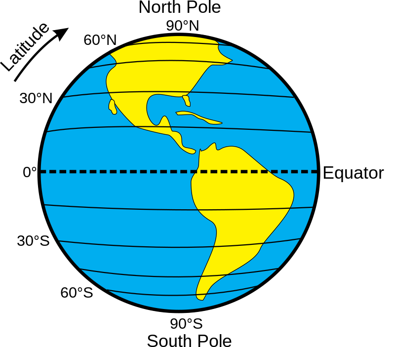
- Latitude: Latitudes are a measure of how far a place is from the equator. The equator's latitude is 0 degrees (0°). The highest latitudes are at the North and South poles. Both are 90°. The climate is very cold at the poles, while the climate is warm and rainy at the equator. The regions between the equator and the poles are temperate and the climates vary but is mostly mild.
- Global Winds: Temperature differences between latitudes cause global winds. These are winds that move air between the equator and poles. Warm air at the equator rises and moves toward the poles. Cold air near the poles sinks and moves toward the equator.
- Ocean Currents: Ocean currents indicate the direction of flow. Some ocean currents may result in movement of warm water from the equator to the poles. There are also currents that move along the latitudes. Togetehr, these currents result in circular patterns in the oceans.
- Distance from water bodies: More than 70% of the earth surface is covered by water. Climates near lakes and oceans are cloudier and rainier than regions farther inland. Summers are cooler. Winters are warmer. Nearness to water reduces temperature extremes. It also increases moisture in the air.
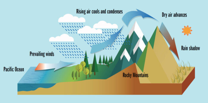
- Altitude: Altitude is a measure of of the height of a place above the sea level. The climate at the base of a mountain is usually warmer than at the peak. Warm air rises up the side of the mountain and as the alititude increases, the temperature reduces. Water vapor in the air condenses to form clouds. As the cloud moves up the side of the mountain, the water droplets become heavy and they fall as precipitation. By the time the air passes to the other side of the mountain, it is dry and cannot cause significant precipitation. so the climate on the other side of the mountain tends to be dry. (Picture credit: Eileen Chontos.)
Lesson 1: The Earth-Sun System
Each planet in the solar system is drawn toward the sun by gravity. Gravity is a force of attraction between two objects. The strngth of the force depends on the mass of the two objects, and the distance between the two objects. The strength of the force decreases as the mass decreases and as the objects are positioned further apart.
The Earth is larger than the Moon so the expectation is that the strength of gravity will be higher on the Earth than on the Moon. In fact, the Moon's gravity is only about one sixth of the Earth's gravity.
Two objects do not have to touch each other to produce a force of gravity between them. The pull of gravity between Earth and the Sun acts across about 150 million kilometers of space. Gravity also acts across roughly 6 billion kilometers of space between the Sun and Pluto. However, because Pluto is located farther away from the Sun, the strength of gravity bwteen the Sun and Pluto is much lower than the gravity between the Sun and the Earth.
The force of gravity between the planets and between the planets and the Sun results in a path that the planets take around the Sun. These paths are called orbits.
As the Earth orbits around the Sun, it is pulled toward the Sun because of gravity but at the same time, inertia makes the planet move away from the Sun. Inertia is defined as the tendency of a moving object to continue moving in a straight line. The combination of gravity and inertia results in planets moving in a nearly cirvular orbit around the Sun called an ellipse.
When Earth is closest to the Sun, it is about 147,000,000 kilometers away. When Earth is furthest from the Sun, it is about 152,000,000 kilometers away.
The Earth moves aroudn the sun at a staggering 30km per second. The Earth's orbit is around 942,000,000 km long, so it takes the Earth about 365 1/4 days for the earth to make a complete trip around the Sun. This is called a Revolution and it is equal to one year.
An imaginary line drawn from the Earth's North to the South pole is called the Earth's axis. The Earth axis is tilted at an angle of about 23o. As the Earth revolves around the Sun, sunlight strikes different parts of the Earth at different angles. The changes in the angle result in seasons. When the Northern Hemisphere is tilted away from the Sun, the ground does not receive much heat energy and temperatures are low. In the Northern Hemisphere, this is the beginning of winter. At the same time, summer begins in the Southern Hemisphere. The Southern Hemisphere is tilted toward the Sun, the ground receives more heat energy and temperatures are warmer. In spring and in fall/autumn, both hemispheres receive equal warmth from sunlight, which makes temperatures mild.
The solar energy that reaches the Earth is called insolation. Insolation does not warm all places on the Earth equally. Because of the shape of the Earth, (sphere) and with an imaginary line (the equator) dividing the earth into two equal hemispheres, the sun strikes with the most vertical angle at or near the equator.


The atmosphere forms layers of gases around the earth. The layer of gsases cloest to the earth is called the trophosphere. This layer is thickest at the equator and thinnest at the poles. Above the trophosphere are the stratosphere, mesosphere, thermosphere, and exosphere.
Gases are more dense closer to the earth surface and become less dense as you move toward the exosphere. Tha gas particles press on the Earth's surface and on everything they surround. The force put on a given area by the weight of the air above it is called Air pressure or Atmospheric pressure. You do not feel this weight because atmospheric pressure pushes in all directions and these pushes balance each other.

Lesson 2: The Earth-Sun-Moon System
The Moon has no atmosphere. Because there is no atmosphere, there are no winds and there is no weather on the Moon. There is no air to block radiation from the Sun or for astronauts to breathe. As a result, the temperatures on the moon can be as high as 123oC or as low as -233oC. Astronauts going to the moon need to wear spacesuits to protect them from the changes in temperature and from radiation. They also need containers of oxygen to breathe.
The cheese like craters on the moon are as a result of rocks traveling through space and hitting the Moon.
As the Moon revolves around Earth, different amounts of light reflect from the Moon’s surface and the Moon appears to change shape. A phase of the Moon is the appearance and shape of the Moon as you see it at a particular time. The phase depends on the location of the Moon in relation to Earth and the Sun.

Eclipse
An eclipse occurs when one object moves in front of another object in space.
A solar eclipse occurs when the Moon passes directly between the Sun and Earth. When this happens, the Moon casts a shadow on Earth. People on Earth see darkness move across the Sun.
A lunar eclipse occurs when the Moon moves into Earth’s shadow and is no longer reached by direct sunlight. This happens when Earth is between the Sun and the Moon.

If you are on Earth in the umbra during a solar eclipse, darkness covers the entire face of the Sun. This is called a total solar eclipse. If you are on Earth in the penumbra during a solar eclipse, darkness covers only part of the Sun. This is called a partial solar eclipse.
In lunar eclipses, Earth’s shadow causes the umbra and penumbra. Lunar eclipses may also be total or partial depending on whether or not the Moon is in the umbra or penumbra.
Tides
The pull of gravity between the Moon and Earth and between the Sun and Earth causes a bulge in the surface of Earth. On the part of Earth’s surface that is rocky, we do not notice this pull. However, the pull can be seen in the oceans and other large bodies of water. This pull causes the tide, or the rise and fall of the ocean’s surface.
When the Sun and the Moon line up and pull in the same direction. This causes higher high tides and lower low tides, called spring tides. The tides with the smallest range between high and low tides occur between these two spring tides. These more moderate tides are called neap tides. They take place when the Sun and the Moon pull in different directions and their pulls partly cancel each other.
Lesson 3: The Solar System
Until 1610, when the telescope was developed by the Astronomer Galileo Galilei, people used to observe the sky using only their eyes. As you learnt in the previous topic that the air in the atmosphere has different densities. As light from stars travels through the air, the changes in density make the faint light of the stars appear fuzzy. Looking through a telescope makes dim objects seem brighter and also makes objects appear larger so more details can be observed.
Telescopes can be placed in space to avoid the interference caused by variations in air density in the atmosphere. In 1990, the Hubble Space Telescope was placed into orbit around the Earth. This and other space telescopes gather more than visible light from objects in space, they can detect heat given off by stars and other space objects.
Radio telescopes are located on Earth and record data from radio waves given off by objects in space. Several dishes focus the waves so the radio waves data can be recorded and computers covert the data into images. Radio waves are not affected by air densities so they can move through the atmosphere without interference.

A solar system is made up of a star and the objects that orbit around it. In our solar system, there are eight planets orbiting the Sun. A planet is a large object that orbits a star. Form neares to the sun, the planets in our solar system include Mercury, Venus, Earth, Mars, Jupiter, Saturn, Uranus and Neptune. The planets travel around the sun in elliptical or nearly circular orbits.
The inner planets are closer to the Sun than the asteroid belt and have surfaces made of rock. These planets are Mercury, Venus, Earth, and Mars. The outer planets are beyond the asteroid belt and have surfaces made of gases. These planets are Jupiter, Saturn, Uranus, and Neptune. Pluto was once known as the ninth planet. Pluto’s elongated orbit and small size were different from the other planets. Because of this, scientists debated whether Pluto should be classified as a planet. In Aug 2006, the International Astronomical Union officially reclassified Pluto as a dwarf planet. Other dwarf planets include Ceres and 2003 UB313, which is larger than Pluto but farther from the Sun.
Planet's unique features:
Jupiter: has the great red spot (aka red eye), which is a huge storm that has been blowing for over 400 years. It is believed that combination of sulfur and phosphorus are in Jupiter's atmosphere gives this storm its red color.
Saturn rings: First observed by Galileo in 1610. They are made of ice and rocks ranging in size from pea size to rocks larger than a house. Jupiter, Uranus and Neptune also have faint rings that are more difficult to observe.
Venus: The surface of Venus shows evidence of violent volcanic activity in the past. Venus has shield and composite volcanoes similar to those found on Earth. Long rivers of lava have also been observed on Venus.
Mars rocks! The dark boulders on the surface of Mars are volcanic rock fragments that have been found on Mars. These rocks look similar to rocks found near lava flows on Earth.
A moon is a natural object (natural satellite) that orbits a planet. Different planets have different numbers and sizes of moons. Generally, the outer planets have more moons. The Earth has only one moon while Jupiter has at least 63 moons. Saturn has 47 moons, Uranus has 27 and Neptune has 13.
An artificial satellite is an object that is put in space by man to orbit around the earth or other planets. These may be to monitor weather or conduct various forms of communication.
Moons vary in size. Ganymede is the largest moon in the solar system. In fact Ganymede is larger than Pluto and Mercury. The Earth's moon is also larger than Pluto and is clearly visible without a telescope.
When small objects in space collide with larger objects, a crater is formed. Craters are bowl-shaped holes on the larger object.
A comet is a mixture of frozen gases, ice, dust, and rock that moves in an elliptical orbit around the Sun.
An asteroid is a rock that revolves around the Sun. Most of the thousands of asteroids in the solar system are located between Mars and Jupiter in the asteroid belt.
An object that crosses paths with Earth and enters the atmosphere is called a meteor. Most meteors burn up before they reach the ground. When a meteor lands on the ground, it is called a meteorite.

Chelyabinsk meteor - 2013
Lesson 4: Stars
A star is an object that produces its own heat and light energy. Stars go through stages from beginning to ending depending on how much hydrogen tha star contains. The star's cycle ends when it stops giving off energy.
All stars form out of a nebula. A nebula is a cloud of gases and dust. Gravity pulls the mass of nebula, which contains a lot of hydrogen atoms and as the atoms move closer they collide with each other producing heat. The temperature increases and when the temperature reaches 10 million degrees Celcius, the hydrogen atoms combine to form Ehlium. This process produces huge amounts of heat and light. This marks the beginning of the formation of a star.
The sun is a star, like other stars, it uses hydrogen as the source of energy. As the heat in the sun increases, it forces the hydrogen at the endge of the sun to expand into space, as the hydrogen moves further away from the center of the sun, it cools slightly and turns red. This stage of the star is called a red giant.
Eventually, all the helium is gone and the star begins to cool off and shrink becoming a white dwarf. A white dwarf is a small dense star that sines with a cooler white light. This is the end of the cycle for medium sized stars.
Stars that start with larger amounts of hydrogen (larger stars) end their cycle differently. After they become red giants the atoms at the core become so hot that they combine to form iron atoms. Eventually the iron gets so hot and explodes into a supernova. Supernovas shine brightly for days or weeks then they fade away.
If a star is very massive, it may end its life as a black hole. A black hole is an object that is so dense and has such powerful gravity that nothing can escape from it,not even light.
The sun is a medium sized star with a temperature of around 6000 degrees celcius. Giant stars are about 100 times larger than the sun and super giant stars are 1000 times larger. Neutron stars are the smalles stars.
Stars that form patterns are called constellations. Constellations were often named after animals, characters from stories, or familiar objects. Some constellations have been extensively useful to both ancient and modern travelers. For example, if you can see either the Big Dipper or the Little Dipper in the night sky, you can follow the line that their stars make to find Polaris, the North Star. If you travel in the direction of Polaris, you will be moving north. If you ever become lost in the woods or at sea, look for Polaris (North star) in the night sky. It will help guide you to safety.

The ancient Greeks divided the sky into 12 sections. They named some constellations after characters from Greek myths, such as Orion, a hunter, and Hercules, a hero.
Light Years
After the sun, the next closest star is called Proxima Centauri and is about 40,000,000,000,000 km away. This distance is so huge and becomes difficult to remember and comprehend. We can use the unit light year, which is equal to the distance that light travels in a year, and is equal to 9.5 billion kilometers. Proxima Centauri is 4.2 light years away from the earth.
Clusters and Binary Stars
Some stars form clusters that may contain more than 100,000 stars. Clobular clusters are shaoed like a sphere. When two stars are close to each other, or somehow overlap and are seen as though they were only one star, they are called binary stars. the prefix -bi stands for 'two'. A star that seems to be blinking might actually be a binary star where one of the stars, the dimmer one, blocks the light from the brighter star.
Lesson 5: Galaxies and Beyond
Galaxies
A galaxy is a huge very distant collection of stars. Each galaxy holds billions of stars.
Galaxies differ in size, age, and structure. Astronomers place them in three main groups based on their shapes: spiral, elliptical, and irregular.
A spiral galaxy looks like a whirlpool. The spiral arms can be tightly or loosely wound around the galaxy’s core, and they often contain a great deal of dust. Some spiral galaxies are barred galaxies. A barred galaxy has a “bar” of stars, gas, and dust through its center. The spiral arms emerge from this bar.
An elliptical galaxy is shaped a bit like a football. It has no spiral arms and little or no dust.
An irregular galaxy has no recognizable shape. The amount of dust and gas varies. The irregular shape may have been caused by collisions with other galaxies.
Our solar system is part of the galaxy called the Milky Way. The stars you see in the sky are part of the Milky Way galaxy. The Milky Way is a spiral galaxy. The stars are grouped in a bulge around a core. All of the stars in the Milky Way, including our Sun, orbit this core. The closer a star is to the core, the faster its orbit is. Several spiral arms extend out from the core. Our solar system is located on one of these spiral arms. The arms contain most of the Milky Way’s gas and dust. We cannot see the center of the Milky Way, because there is dust between us and the core. However, from Earth we can see more stars when we look in the direction of the galaxy’s center than when we look in other directions.
The Big Bang Theory
The Big Bang Theory hypothesizes that the universe started with a big bang a single point and has been expanding ever since. Scientific evidence indicates that the big bang happened 13.7 billion years ago.
Astronomers think the galaxies must have been closer to each other in the past. The early universe was very dense, and its temperature was high. At the beginning moment, the universe was extremely tiny, hot, and dense. From this tiny beginning, the universe expanded rapidly. This expansion sent matter out in all directions.
The galaxies continue to move outward. Evidence for the big bang comes from background radiation. Background radiation comes from all directions in space. This radiation is left over from the beginning moments of the universe.
How did Earth form?
Scientists think that Earth is about 4.6 billion years old and theorise that the Earth and its atmosphere developed in a series of stages. The process began in the nebula that formed the Sun. Dust and ice particles moved within the nebula, occasionally colliding. They merged and stuck together. The clumps of particles grew until they became the young Earth, or proto-Earth. Over time, proto-Earth became large enough that its gravity could hold an atmosphere. Scientists believe that the atmosphere did not initially contain oxygen, as it does today. Atmospheric oxygen developed as a waste product of photosynthesis.
Careers in Science
Aerospace Engineer
Aerospace engineers complete a degree program in aerospace engineering from a recognized university. As an aerospace engineer, you could make flights into space possible by helping build highspeed spacecraft. You could also make travel closer to Earth faster and safer by improving aircraft design. Therefore, aerospace engineering is for those interested in designing spacecraft, missiles, helicopters, or military jets.
